Svinesund bridge on the border of Norway and Sweden.
Photo: iStock
Photo: iStock
2. Methodology
In this section the process by which the case studies were selected is detailed. Each chosen case study is then described in more detail, and finally a description is given of how the data were collected.
2.1. Case Selection
The study started by identifying potentially relevant case study areas on the borders of Sweden and Norway, Sweden and Denmark and Sweden and Finland. Nine such potential cases were identified in the Nordic countries based on desk research, with the focus being on urban-urban cross-border integration. That is understood as sustained flows between relatively densely populated areas such as flows generated by commuting workers or students, flows generated by patients or customers seeking cross-border services such as hospitals, cinemas or events, and local flows of goods crossing borders.
Following review of their characteristics, three areas situated along the borders of Sweden’s three neighbouring countries were chosen, to illustrate various contexts and cross-border challenges. In particular, the cases were selected to allow for representation of varying degrees of urbanisation. Based on information gathered through desk research, locations with established collaboration projects or plans to increase and develop urban-urban connections across borders were deemed to be of particular interest.
The selected case studies involving different Nordic countries are Haparanda and Tornio on the border of Sweden and Finland, Strömstad, Dals-Ed and Halden on the border of Sweden and Norway, and Helsingborg and Helsingør on the border of Sweden and Denmark. The case of Haparanda and Tornio illustrates the challenges of a cross-border town. The twin cities have a long history of cross-border cooperation that formally started in 1987, with notable achievements including a common marketplace inaugurated in 2011 and a common travel centre (Tornio, 2023). The cities of Strömstad, Dals-Ed and Halden form part of the Svinesund region. They showcase the need for collaboration in a region with cross-border commuting across less densely populated areas. The case of Helsingborg and Helsingør illustrates the challenges of commuting and planning not only across a border, but also a sea since the two cities are separated by the Øresund Strait. Currently the only direct link between the cities is by public boat service.
2.2. Data Collection
In the initial stage, desk research was performed to gather information on potential case studies in the Nordic Region. Existing reports, strategies and websites from municipal and regional authorities or cross-border committees were screened to gain an overview of the characteristics of the locations.
Representatives of the municipalities, regions and cross-border committees were selected as potential interviewees. Semi-structured interviews were then conducted between autumn 2023 and spring 2024, with the questions focusing on cross-border relations, planning strategies, and future outlooks.
2.3. Description of the Case Studies
2.3.1. Haparanda–Tornio
City | Country | Pop. | DEGURBA class | Language |
Haparanda | SE | a 9,177 | Intermediate density area | Swedish, Meänkieli |
Tornio | FI | a 21,018 | Intermediate density area | Finnish |
Table 1: Population, degree of urbanisation and spoken language for the cities in the case study.
a in 2023.
Data: Eurostat 2020b; Statistics Finland, 2024b; Statistics Sweden (SCB), 2024a.
a in 2023.
Data: Eurostat 2020b; Statistics Finland, 2024b; Statistics Sweden (SCB), 2024a.
The twin city of Haparanda and Tornio, located far north in the Tornedalen on the border between Sweden and Finland, is an interesting example of a relatively small international city (see figure 1). It is situated by the main land link between Sweden and Finland where the railway between Luleå and Oulu crosses the border. The railway section is currently being electrified (Ainonen 2023). The two cities have a long history of cross-border cooperation, with the two countries sharing several facilities, including a joint tourism office, a common marketplace and museums (Ainonen 2023). The two cities have built strong links including a common primary school, where the children speak their own native tongue.The Swedish and Finnish languages do not have common roots, which can pose a challenge to cross-border cooperation. However, it should be noted that many inhabitants of Tornedalen on the Swedish side speak or understand Meänkieli, which is also referred to as Tornedals Finnish (Institutet för språk och folkminnen, 2023). A further challenge is that the cities are in two different time zones.
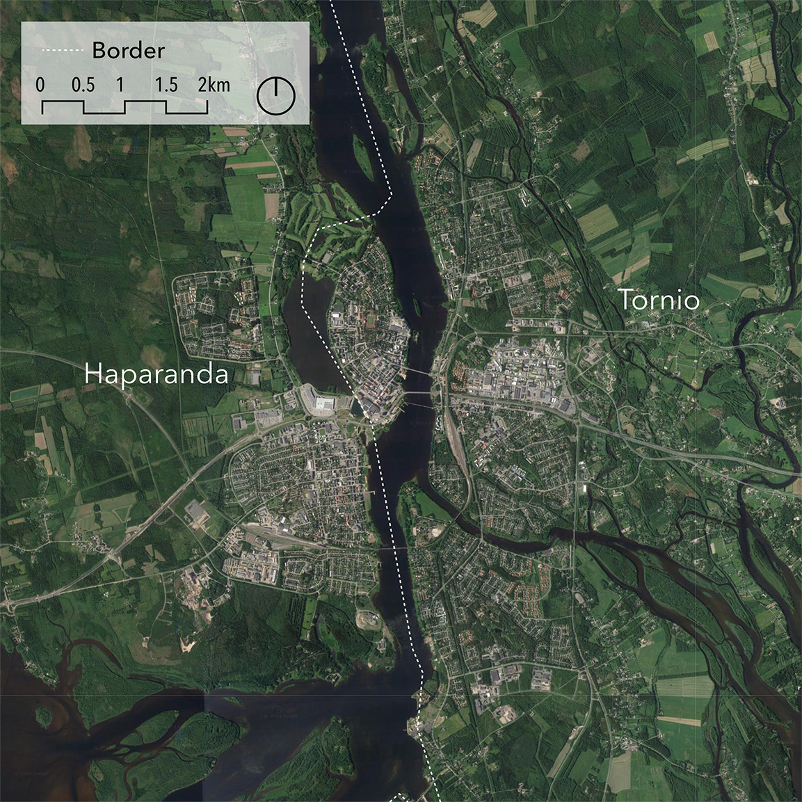
Figure 1: Map of Haparanda, Sweden and Tornio, Finland.
Data: Eurostat 2020a and Google Earth.
Data: Eurostat 2020a and Google Earth.
Tornio’s population is twice that of Haparanda, with over 20,000 inhabitants in 2022 (see table 1). According to Eurostat’s Degree of Urbanisation classification, which categorises municipalities as either urban, intermediate, or rural, both Haparanda and Tornio belong to the intermediate category (see table 1), meaning that they have a moderate degree of urbanisation (Eurostat 2020b). Figures 2 and 3 provide a more nuanced view of what types of territories can be found within the municipalities. The figure is based on Nordregio’s grid-based urban–rural typology (Stjernberg, Vasilevskaya and Penje, 2024), which classifies all Nordic territories into seven different typology classes based on differing degrees of urbanity and rurality. It can be seen that the majority of the population in Haparanda lives in the typology class of urban centre in a rural area, whereas the population in Tornio predominantly lives in rural heartland areas.
Figure 2: Population by Nordic urban-rural typology for Haparanda Sweden and Tornio, Finland.
Data: Nordregio, based on Stjernberg, Vasilevskaya and Penje, 2024.
Data: Nordregio, based on Stjernberg, Vasilevskaya and Penje, 2024.

Figure 3: Map of the Nordic urban-rural typology for Haparanda, Sweden and Tornio, Finland.
Data: Eurostat 2020a and Google Earth; Nordregio, based on Stjernberg, Vasilevskaya and Penje, 2024.
Data: Eurostat 2020a and Google Earth; Nordregio, based on Stjernberg, Vasilevskaya and Penje, 2024.
Tornio’s business sector is focused on the steel industry, mechanical engineering, commerce and tourism (House of Lapland, 2022). Tornio hosts a large stainless steel manufacturing plant using raw materials from the mining site of the neighbouring municipality of Kemi. The plant boasts of being among the most integrated and energy-efficient stainless steel factories and benefits from an on-site port for shipping finished products (House of Lapland, 2018). The plant owner, Outokumpu, employs 2,150 people at the Tornio and Kemi sites, in addition to 300 daily contractors and also creates some 7,000 indirect jobs (House of Lapland, 2018). Health services in Norrbotten rely on Finnish employees, in particular nurses (Sjaunja 2024). Haparanda’s main private employer is IKEA with 175 employees (SCB 2024b).
Tornio’s unemployment rate is slightly lower the rates in the region of Lapland and in Finland (see figure 4). As shown in figure 4, the Finnish unemployment rate was higher than in Sweden throughout the time period in question. Though Haparanda’s unemployment rate is far lower than in Tornio, it is consistently higher than the Swedish national rate and well above the regional rate in Norrbotten.
Figure 4 : Unemployment as a percentage on both sides of the Swedish-Finnish border, at the national, regional and municipal level from January 2020 to January 2024.
Data: Statistics Finland, 2024a; Statistics Sweden (SCB), 2024c.
Data: Statistics Finland, 2024a; Statistics Sweden (SCB), 2024c.
2.3.2. Strömstad–Halden–Dals-Ed
City | Country | Pop. | DEGURBA class | Language |
Halden | NO | a 31,730 | Intermediate density area | Norwegian |
Strömstad | SE | a 13,476 | Intermediate density area | Swedish |
Dals-Ed | SE | a 4,606 | Thinly populated area | Swedish |
Table 2: Population, degree of urbanisation and spoken language for the cities in the case study.
a in 2023.
Data: Geoportal of the European Commission (Eurostat), 2020b; Statistics Norway (SSB), 2024b; Statistics Sweden (SCB), 2024a.
a in 2023.
Data: Geoportal of the European Commission (Eurostat), 2020b; Statistics Norway (SSB), 2024b; Statistics Sweden (SCB), 2024a.
The second case study area is located in the Svinesund region by the southern part of the border between Sweden and Norway. The cities of Strömstad and Dals-Ed on the Swedish side have ties to the city of Halden on the Norwegian side. Halden has a larger population than both the Swedish cities (see table 2). Strömstad is connected by road to Halden, with the journey taking around 30 minutes by car along the E6 thoroughfare and the Svinesund Bridge. Public transport between the cities is limited to buses, with the trip taking about an hour in total. Dals-Ed and Halden are connected by road and railway. Train travel is quicker, taking around 40 minutes compared to around 50 minutes by car (see figure 5).
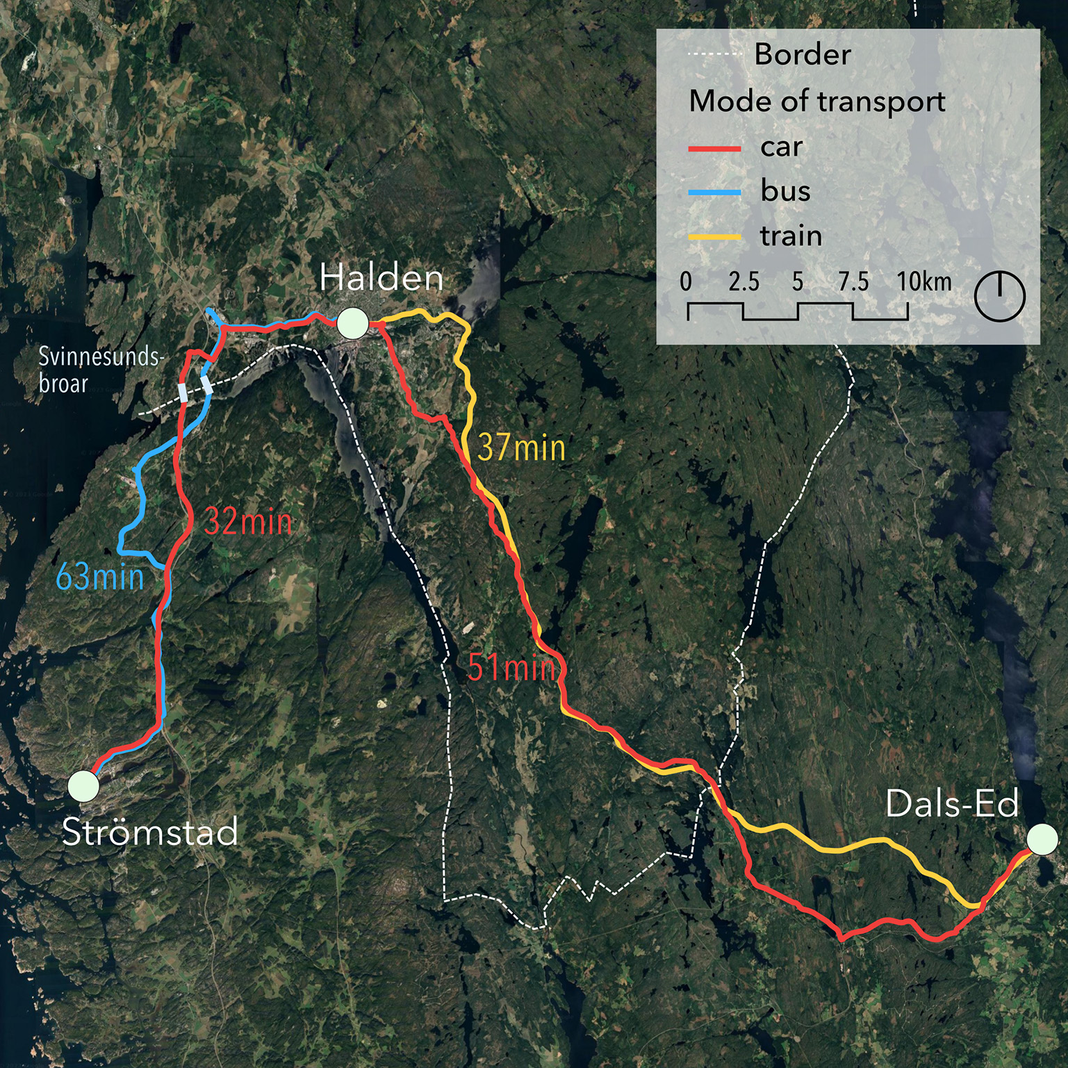
Figure 5: Map of Strömstad, Sweden, Dals-Ed, Sweden and Halden, Norway.
Data: Eurostat 2020b, Google Earth, OpenStreetMap/Openrouteservice, Trafikverket,Bane NOR SF, Eurostat 2020a.
Data: Eurostat 2020b, Google Earth, OpenStreetMap/Openrouteservice, Trafikverket,Bane NOR SF, Eurostat 2020a.
The population of Strömstad is about half that of Halden and nearly three times that of Dals-Ed (see table 2). The population of Halden is mostly urban, while half of Strömstad’s population lives in the centre and half in rural heartland areas (see figures 6 and 7). Dals-Ed is more rural and is situated in the north-western part of Dalsland in an area of wilderness featuring some 400 lakes and rivers (Dals-Eds kommun, 2023). All of its population lives in rural heartland or sparsely populated rural areas (see figure 6). Both Halden and Strömstad have an intermediate degree of urbanisation (see table 2). Some residents of Strömstad and of Dals-Ed commute to Halden for work and some local businesses have ties across the border.
Figure 6: Population by Nordic urban-rural typology for Strömstad, Sweden, Dals-Ed, Sweden and Halden, Norway.
Data: Nordregio, based on Stjernberg, Vasilevskaya and Penje, 2024.
Data: Nordregio, based on Stjernberg, Vasilevskaya and Penje, 2024.
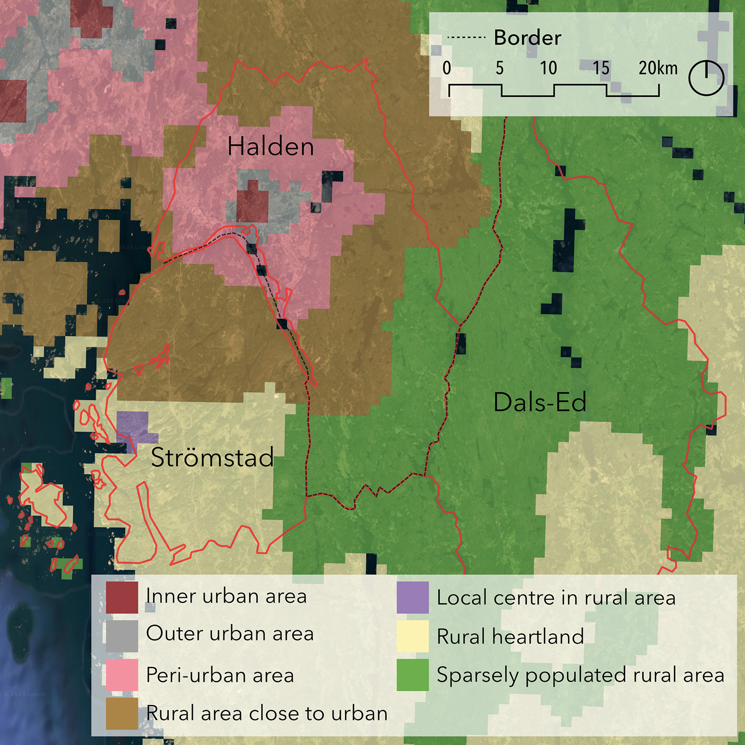
Figure 7: Map of the Nordic urban-rural typology for Strömstad, Sweden, Dals-Ed, Sweden and Halden, Norway.
Data: Eurostat 2020a; Nordregio, based on Stjernberg, Vasilevskaya and Penje, 2024.
Data: Eurostat 2020a; Nordregio, based on Stjernberg, Vasilevskaya and Penje, 2024.
Halden’s economy benefits from collaboration with Østfold University College and the Institute for Energy Technology (Halden Kommune, 2023). Since 1958, the Halden Reactor Project has been in operation and is currently focused on research related to nuclear safety (NEA 2024). Halden is host to industries in the fields of information technology, electronics, chemistry and production, in particular the cable manufacturer Nexans. Halden also has a long history of timber production (Halden Kommune, 2023).
Strömstad benefits from its proximity to the Norwegian border with many businesses within the hospitality industry. The city also hosts companies operating in the fields of environmental technology and pharmaceuticals and is home to the only Swedish national marine park (Strömstads kommun, 2022). The border shutdown at the height of the Covid-19 pandemic dramatically highlighted the importance of cross-border exchanges to Strömstad’s economy. Figure 8 shows the high impact of the lockdown and of reduced cross-border shopping on the unemployment rate in Strömstad compared to the national and regional rates. In early 2020, the unemployment rate in Strömstad was between 4 and 5%, well below the regional average and the Swedish national average and close to the unemployment rate in Dals-Ed. In March 2021, it hit 9.36%, two percentage points higher than the Swedish national average (SCB 2024).
The Covid-19 lockdown also had a critical impact in Halden, where the unemployment rate increased dramatically to 11% in March 2020 from less than 4% in February (NAV 2024b). However the unemployment rate had halved again by June 2020, coming back into line with the national Norwegian rate (Statistics Norway (SSB), 2024a).
Figure 8: Unemployment as a percentage for the municipalities of Dals-Ed,Strömstad and Halden, the regions of Västra Götaland and Østfold/Viken as well as for Sweden and Norway from January 2020 to January 2024.
Data: Arbeids- og velferdsetaten (nav), 2024a, 2024b; Statistics Norway (SSB), 2024a; Statistics Sweden (SCB), 2024c.
Data: Arbeids- og velferdsetaten (nav), 2024a, 2024b; Statistics Norway (SSB), 2024a; Statistics Sweden (SCB), 2024c.
Halden, Strömstad and Dals-Ed form part of the Svinesund Committee, a cross-border committee initiated in the 1980s that brings together politicians from both sides of the border with participation and support from Region Västra Götaland in Sweden and from the region of Viken in Norway. The committee is based on cross-border political cooperation between Swedish and Norwegian municipalities, Østfold county municipality, and Region Västra Götaland with the focus being on blue and green growth, tourism and border opportunities (Svinesund Committee, 2024). The committee’s missions include providing institutional infrastructure to facilitate cross-border political collaboration and development for local and regional actors, carrying out cross-border development projects, alleviating obstacles to regional opportunities, relaying regional cross-border concerns at the national level and contributing to the cooperation plan of the Nordic Council of Ministers for regional development and planning (Svinesund Committee, 2024).
2.3.3. Helsingborg–Helsingør
City | Country | Pop. | DEGURBA class | Language |
Helsingborg | SE | a 151,306 | Densely populated area | Swedish |
Helsingør | DK | a 63,865 | Intermediate density area | Danish |
Table 3: Population, degree of urbanisation and spoken language for the cities in the case study.
a in 2023.
Data: Geoportal of the European Commission (Eurostat), 2020b; Statistics Denmark (DST), 2024b; Statistics Sweden (SCB), 2024a.
a in 2023.
Data: Geoportal of the European Commission (Eurostat), 2020b; Statistics Denmark (DST), 2024b; Statistics Sweden (SCB), 2024a.
The third case study focuses on Helsingborg on the west coast of Sweden and Helsingør. This case highlights the challenges of cross-border urban planning across a body of water. The two cities are strategically located at the shortest link between Sweden and Denmark, separated by less than 5km (less than half the distance spanned by the Öresund Bridge between Malmö and Copenhagen).
A boat connection carries passengers, cars and lorries over the strait, with the journey taking around 20 minutes (see figure 9). Discussions on the creation of a fixed road and railway link to improve transport reliability, capacity and security are underway (Lundgren, Löfving and Westin, 2023). The cities form part of the Greater Copenhagen Region. Helsingborg is about 40 minutes away from Malmö by car and by train and about 80 minutes from Copenhagen across the Öresund Bridge. Helsingør is within an hour of Copenhagen by train and car.
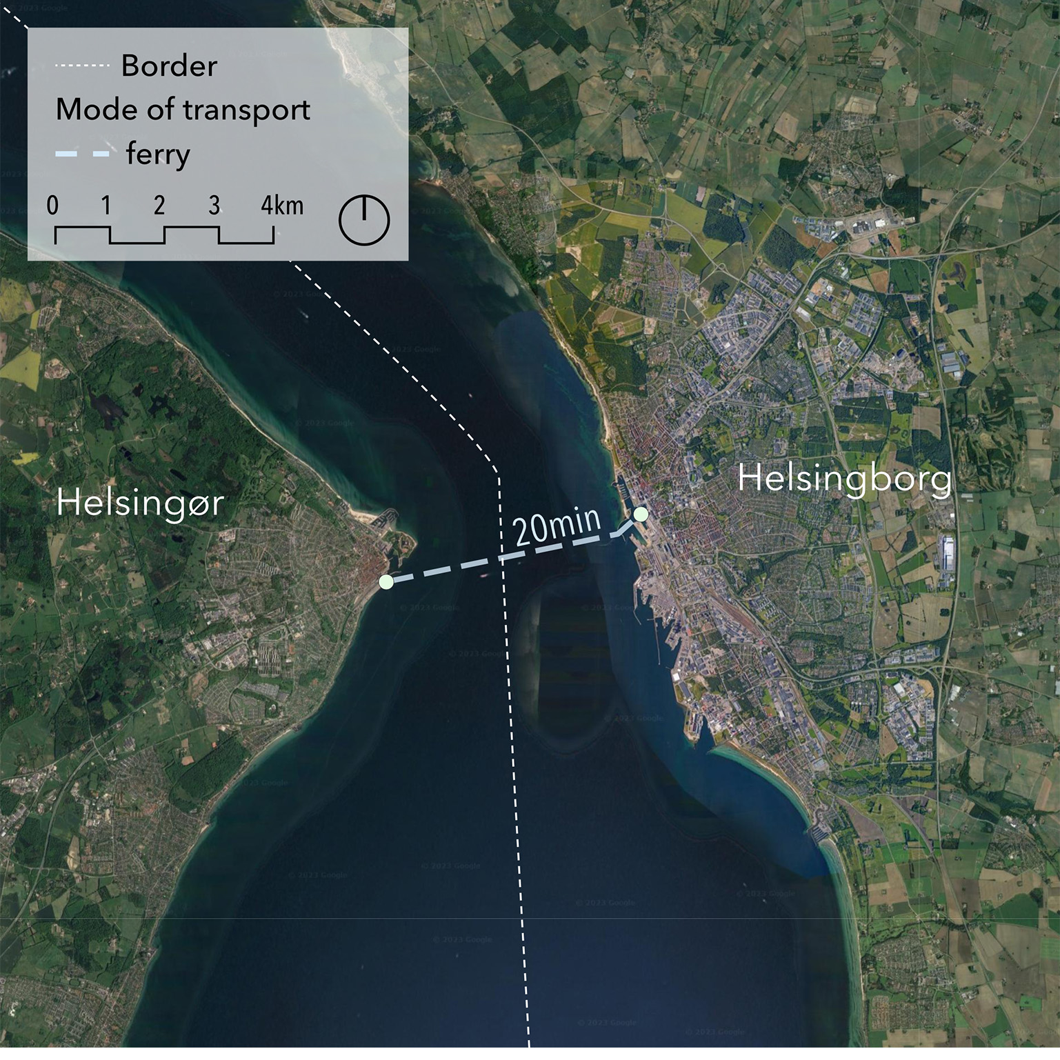
Figure 9: Map of Helsingborg, Sweden, and Helsingør, Denmark.
Data: Eurostat 2020a and Google Earth.
Data: Eurostat 2020a and Google Earth.
The population of Helsingborg is more than twice that of Helsingør. Helsingborg is urban while Helsingør has a moderate degree of urbanisation (see table 3). Both cities have a large majority of their populations living in urban areas, namely inner urban, outer urban or peri-urban areas (see figures 10 and 11). Helsingborg has larger inner urban areas and a higher proportion of its population living in such areas.
Figure 10: Population by Nordic urban-rural typology for Helsingborg, Sweden, and Helsingør, Denmark.
Data: Nordregio, based on Stjernberg, Vasilevskaya and Penje, 2024.
Data: Nordregio, based on Stjernberg, Vasilevskaya and Penje, 2024.
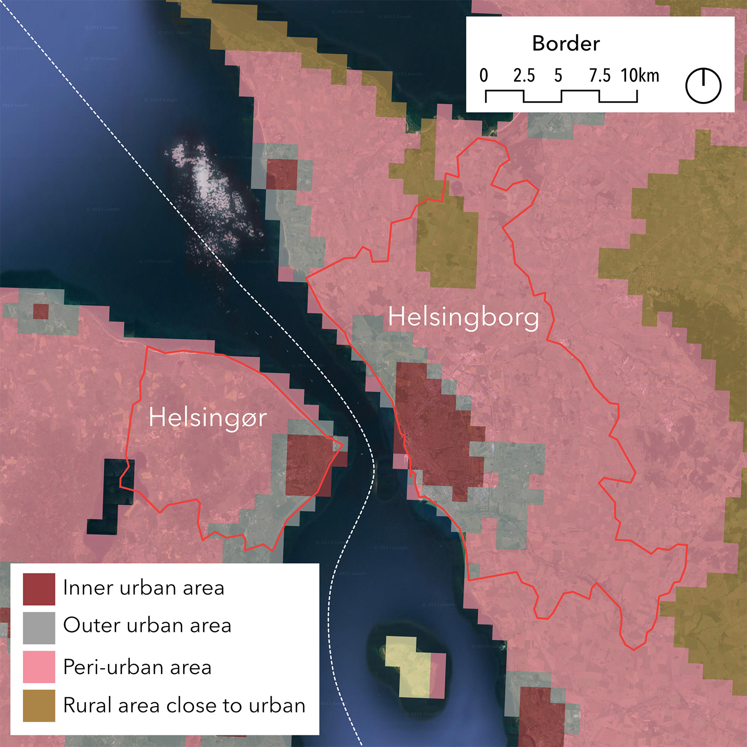
Figure 11: Map of the Nordic urban-rural typology for Helsingborg, Sweden and Helsingør, Denmark.
Data: Eurostat 2020a, Google Earth and Nordregio, based on Stjernberg, Vasilevskaya and Penje, 2024.
Data: Eurostat 2020a, Google Earth and Nordregio, based on Stjernberg, Vasilevskaya and Penje, 2024.
Helsingborg had a relatively high unemployment rate of between 8% and 10% during the 2020–2024 period, as shown in figure 13. Its unemployment rate is consistently higher than the regional rate in Skåne (1 percentage point higher) and higher than both the Swedish national rate (3 percentage points higher) and the Danish national rate (5 percentage points higher), see figure 12. The unemployment rate in Helsingør and in the region of Hovedstaden is close to the Danish national rate. In 2021, 27% of the 76,782 inhabitants in employment commuted from Helsingborg to their workplace (Helsingborg, 2024). An analysis by Statistics Denmark found that an estimated 700 people living in Sweden commuted to Helsingør to work in 2022 (Søndergaard Møller, Stender and Thrane, 2023). Comparable up-to-date statistics for Danish workers in Helsingborg could not be found. However, the number of people crossing the strait each year was over 7.5 million in 2015 and expected to increase (HH-samarbete, 2016).
Figure 12: Unemployment as a percentage for the municipalities of Helsingborg and Helsingør, at the regional level for Skåne and Hovedstaden and at the national level for Sweden and Denmark from January 2020 to January 2024.
Data: Statistics Denmark (DST), 2024c, 2024a, 2024b; Statistics Sweden (SCB), 2024c.
Data: Statistics Denmark (DST), 2024c, 2024a, 2024b; Statistics Sweden (SCB), 2024c.
Helsingborg and Helsingør work together on several committees. At the local level, they cooperate within the HH-sammarbete, a dedicated cooperation scheme that aims to improve the quality of life and growth in the region around northern Öresund and brings Helsingør and Helsingborg together to work on joint strategies (HH-samarbete, 2016). The strategy is based on the vision of two cities becoming one cohesive city by 2035. The cohesion focuses on the labour market, urban life, infrastructure, schools and culture and revolves around the concept of a borderless region. Being part of the Greater Copenhagen Region, they cooperate with municipalities of varying sizes in the area, as well as with the regions (Greater Copenhagen, 2024). Since they are strategically located on the narrower section of the strait, another important form of cooperation is the String megaregion, which connects actors along the corridor between Hamburg and Oslo (String, 2024).
2.4. Nordic Workshop in Copenhagen
A workshop involving stakeholders from municipalities, regions and national authorities from Sweden, Norway, Finland and Denmark was organised in conjunction with the Värmland-Østfold cross-border committee in March 2024 in Copenhagen. Most of the participants were members of the Nordic cross-border committees
See https://www.norden.org/en/information/contact-details-border-committees for links to the webpages of the committees.
For the workshop, we mapped the various cross-border services for each case. To accompany the maps, we grouped the four types of cross-border collaboration in a table that we placed alongside the maps. We completed the tables using information gathered from our research and data collected during the interviews.
The interviews and desk research highlighted four sharing-potential axes, which were used to frame the group discussions during the workshop and are presented in the “Results” and “Discussion” sections of this report. We structured the workshop around cross-border challenges, sharing-potential and national support.