Noteworthy practices
Different transport users meet at a pedestrian crossing in Copenhagen. Source: Pedro Netto/Unsplash.com
In April 2026, the Nordic Cycle Network conducted a two-day workshop in Oslo. Participants from the Office for Cycle Superhighways in Copenhagen and the City of Oslo (among others) showcased several practices of multi-use infrastructure from their respective contexts. The following section discusses some of the practices introduced and debated during the workshop. The examples provided here are meant both as inspiration but also a point of departure for discussion among other Nordic practitioners seeking to design safer and high quality shared infrastructure in their own cities and regions.
Oslo’s cycling infrastructure progress
Oslo has extensive experience in designing multi-use infrastructure for traditional micromobility modes, while also adapting its planning approach to accommodate emerging forms of mobility. The City has made significant investments in the past decade to provide sufficient space for all types of cyclists using the cycling paths comfortably and securely. According to their cycling strategy, the municipality categorises different types of cycling infrastructure according to their design. Cycling routes (sykkelvei) with sidewalks should be the standard solution for cycling routes outside of the most densely populated areas of Oslo and where intersections are few (Oslo kommune, 2015). For roads with speed limits from 30 to 50 km/h that have high daily traffic volumes, dedicated cycling lanes (sykkelbane) should be established. Cycling lanes should be physically separated from the motorised traffic lanes and run in the same direction as the rest of the traffic. Car parking is generally be prohibited around cycling lanes (sykkelfelt), which are separated from motor vehicles only by painted markings on the road. The first bicycle-priority street (sykkelgate) with broad sidewalks and a dedicated cycling lane in the middle of the street was implemented in 2024 on Løvenskiolds gate in the Frogner neighbourhood (see below). Such cycling streets are useful in dense urban environments as they allow for safe cycling while providing enough space for other urban mobility. While cyclists are legally allowed to ride on the sidewalk in Norway, future planning is focused on phasing out such practice as combined pedestrian and cycling streets are not considered an ideal solution. The municipality created a graph that illustrates the strategic planning and rationale for determining which type of cycling infrastructure should be implemented and when (see Figure 2).
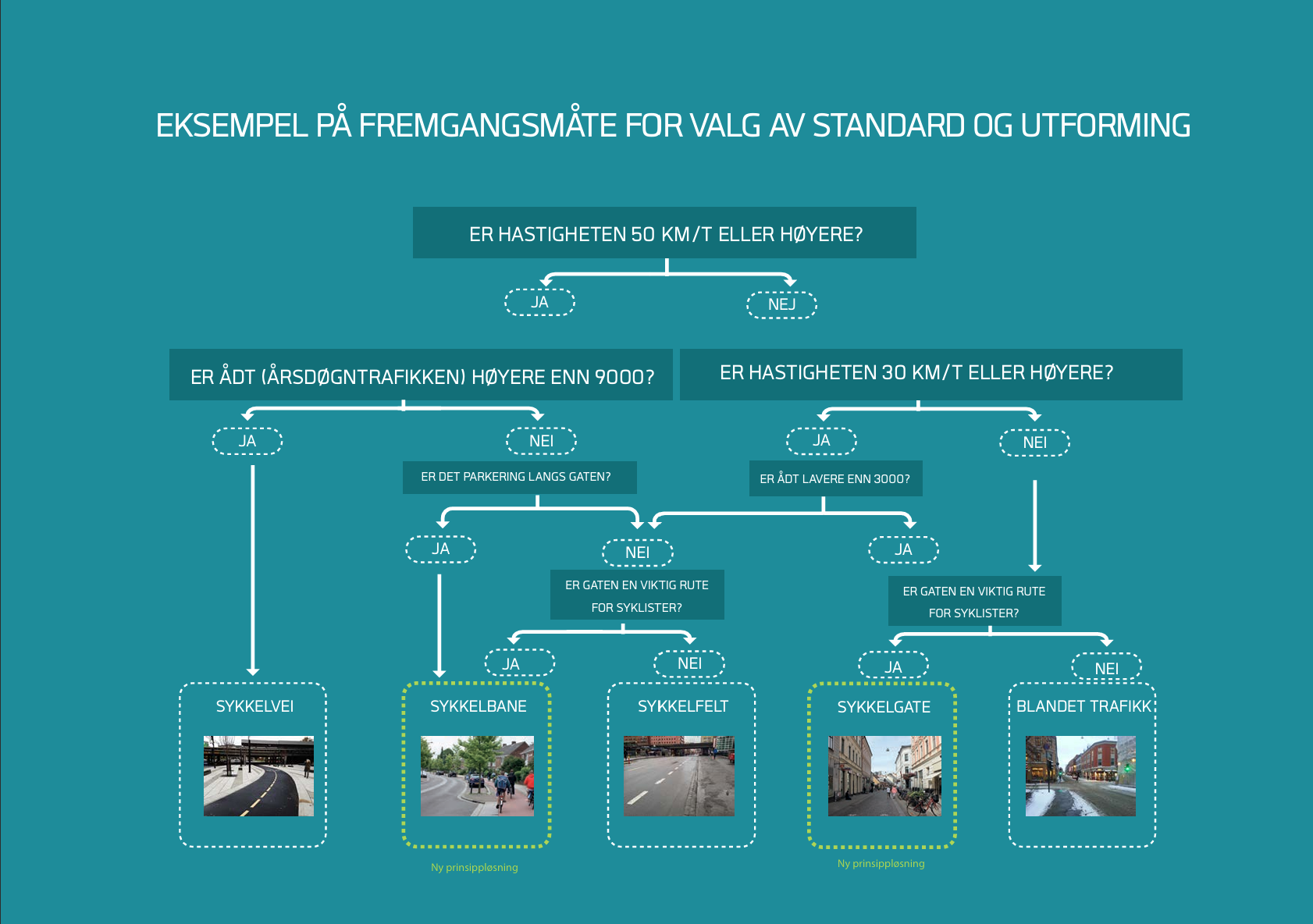
Figure 2. Examples for selecting standards and design of streets Oslo. (Source: Oslo kommune, 2015)
The successful transformation of Oslo’s cycling infrastructure can be attributed to prioritising immediate measures and quick fixes on the roads while simultaneously working on long-term planning for larger projects. This was made possible due to a shift in political leadership that placed greater emphasis on cycling and allowed converting street parking into cycling lanes. Since 2015, Oslo removed 6,000 parking spaces for cycling lane development and reached its peak in 2022 when 26 km of newly built lanes were finalised. Comprehensive traffic plans can take up to 10 years to complete, while rapid adjustments, such as cycle lane painting, can take from one week to one year. While the highest quality infrastructure takes time to implement, these short-term fixes are also highly beneficial, especially when many are made throughout the city. As mentioned before, Oslo is moving away from developing separate cycling and mobility strategies. Future documents will adopt a more holistic approach in the form of an interdisciplinary mobility strategy, considering cycling in relation to other modes of transport and placing greater emphasis on encouraging car users to begin cycling.
Løvenskiolds gate: Bicycle-priority street with continuous footpath
Previously a car-oriented street with car parking along both sides, Oslo’s Løvenskiolds gate has been redesigned with the characteristic red surface that gives cyclists priority over motorised vehicles (Figure 3). Specialised rising bollards were placed at each end of the cycle street to limit or prevent cars from entering the area during certain occasions. As the street passes through a residential neighbourhood, parking has been retained along the sides; however, the parking spaces are now separated from the main cycling lane by a strip of cobblestones, allowing car users to open their doors without disrupting the flow of bicycle traffic.
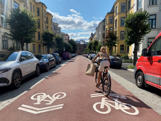
Figure 3. The revised design of Løvenskiolds gate accommodates cyclists as the primary street user while maintaining pedestrian-friendly space and some vehicle parking. (Source: City of Oslo)
Another example from this project is the design of a continuous footpath constructed on Løvenskiolds gate (Figure 4) and on several other streets in Oslo. The continuous footpath ensures that the sidewalk is kept at the same level while the roadway is raised over the intersection (Figure 4). The design signals that pedestrians have priority at the crossing while functioning as a speed bump for cyclists and cars.
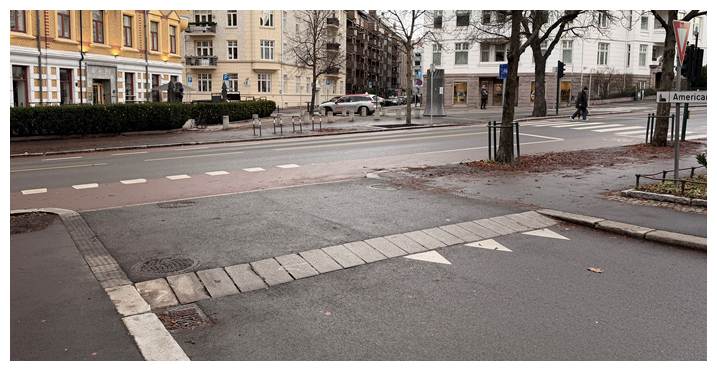
Figure 4. The sidewalk design offers continuity for pedestrians, signalling other road users to proceed with caution. (Source: City of Oslo)
The municipality gathered feedback from street users about both solutions to evaluate the impacts. They found that the bicycle-priority street design increased legibility and perception of safety among cyclists due to fewer conflicts. Street users generally perceived that the street had improved compared to the former design. Few conflicts have been observed on the continuous footpath and there are more negotiated interactions among road users. However, due to the unconventional design, some uncertainty remains regarding the traffic rules.
Shared cycle superhighway design in the Capital Region of Denmark
The Office for Cycle Superhighways in Denmark’s Capital Region has made an analysis of a cycling route called Avedøreruten which runs through natural landscapes along the water (Figure 5). The 9-km long route has minimal intersections with motorised vehicles but is oftentimes used by race cyclists, pedestrians, and joggers, as well as commuting cyclists on both electric and standard bikes. While the Office of Cycle Superhighways does not generally recommend developing multi-use paths on cycle superhighways due to potential conflicts between slower-moving pedestrians and faster travellers, the route is classified as a multi-use path in which different types of users share the space without distinct priority.
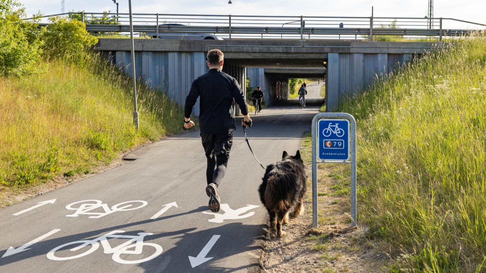
Figure 5. Markings along Avedøreruten indicate an intended traffic flow among users; however, actual use varies considerably based on individual needs or alternative movements that feel intuitive to each user. (Source: Cycle Superhighways, Capitol Region, Denmark)
After assessing the route to identify potential conflicts, the results showed that users were generally satisfied with the path, and only one-third of respondents experienced conflicts. The Office also used their Route Assessment Tool, which provides a method to evaluate path types and cross-sections, intersections and potential stops, the pavement, visibility and lighting, wayfinding and service measures, and maintenance. Applied to Avedøreruten, the route scored low on path type and cross-sections, meaning that possibilities for conflicts remain present. The analysis showed that conflicts primarily arose due to uncertainties around where pedestrians should position themselves in relation to passing cyclists given the width of the space and high speeds of some who pass by. In some parts of the path, markings designate where cyclists and pedestrians are encouraged to move according to their direction of travel; however, the markings are not always intuitive and are overruled by the comfort and perceived safety of users among their fellow users and the surrounding environment. Nevertheless, improved lighting during dark hours and the route’s long, continuous straight stretches have helped maintain visibility, reduce potential conflicts, and invite residents with all mobility interests to enjoy the public space.
There are plans to expand the current Avedøreruten by upgrading the Kalvebodfælledruten, another nearby path which also runs primarily through natural environments. While in some sections, the new route is in proximity to residential areas with a higher degree of intersecting pedestrian paths, the Office for Cycle Superhighways expects to overcome future challenges by conducting additional route analyses.