3.2 Comparing the Nordic typology with the DEGURBA classification
Following the previous sections where urban–rural differences were briefly examined according to the Eurostat DEGURBA classification and then according to the Nordic urban–rural typology (Section 3.1), this section draws on both these territorial classifications and examines how well the two classifications match each other. The key question addressed in this section is what kind of differences in territorial and settlement patterns can be seen within urban, intermediate, and rural municipalities? The answer sheds light on how heterogeneous the Nordic municipalities are. Throughout the analysis the purpose was to show how the grid-based Nordic typology can be used to complement the municipality-level DEGURBA classification and further nuance the picture of territorial differences across the Nordic countries.
The diversity of Nordic urban, intermediate, and rural municipalities
For the analysis in this section, the seven different typology classes of the Nordic urban–rural typology have been grouped into three further general combined Nordic typology classes (see Table 4) as follows:
- Inner urban areas and outer urban areas are examined together as urban areas.
- Peri-urban areas and rural areas close to urban areas are combined into a category of intermediate areas.
- Local centres in rural areas, rural heartland areas, and sparsely populated rural areas are examined as a combined class of rural areas.
The new groups better correspond to the three-class DEGURBA classification.
Figure 29 shows to what degree the Nordic urban–rural typology and the DEGURBA classification correspond to each other when classifying Nordic municipalities based on the Nordic typology class; this being most common in each municipality, when considering how much of the land area belongs to the different typology classes.
Table 4. The seven detailed territorial classes and combined general territorial classes in the Nordic urban–rural typology.
Combined Nordic typology classes | Detailed Nordic typology classes |
Urban areas |
|
Intermediate areas |
|
Rural areas |
|
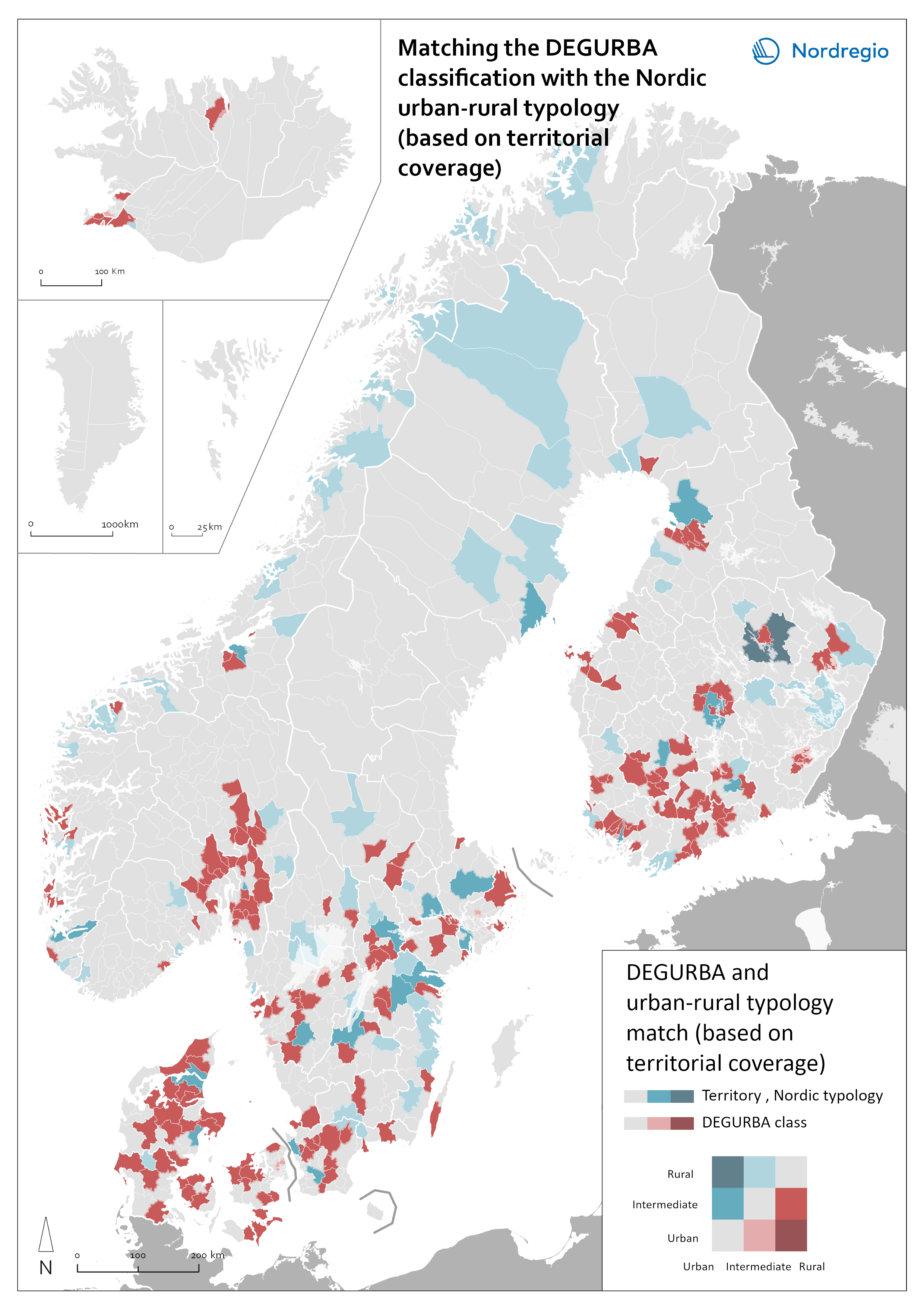
In Figure 29 most municipalities are coloured grey. This colour represents municipalities where the Nordic typology and the DEGURBA classification correspond well to each other; the map shows that most Nordic municipalities fall into this category. This means that, for instance, in a municipality that is classified as rural in DEGURBA, then the most common territorial class in the Nordic typology is one of the rural typology classes. However, there are also some municipalities that are coloured either red or blue. These represent municipalities where there is a more noticeable difference between the two territorial classifications.
For example, the City of Kuopio, located in Eastern Finland (shown in dark blue in the map in Figure 29) is classified as an urban municipality according to DEGURBA, while the land area is predominantly rural in the Nordic typology. According to the Nordic typology, in Kuopio, approximately 76% of the land area is classified as rural, 21% as intermediate, and only 3% as urban (see Figure 31). Figure 30 shows a magnified image of Kuopio, indicating clear internal territorial differences and rather unevenly distributed settlement patterns within the municipality. The inner urban areas and, to a lesser extent, the outer urban areas have a significantly higher population density and contain most of the population in the municipality; rural heartland areas and especially sparsely populated rural areas, on the other hand, have a rather low and dispersed population.
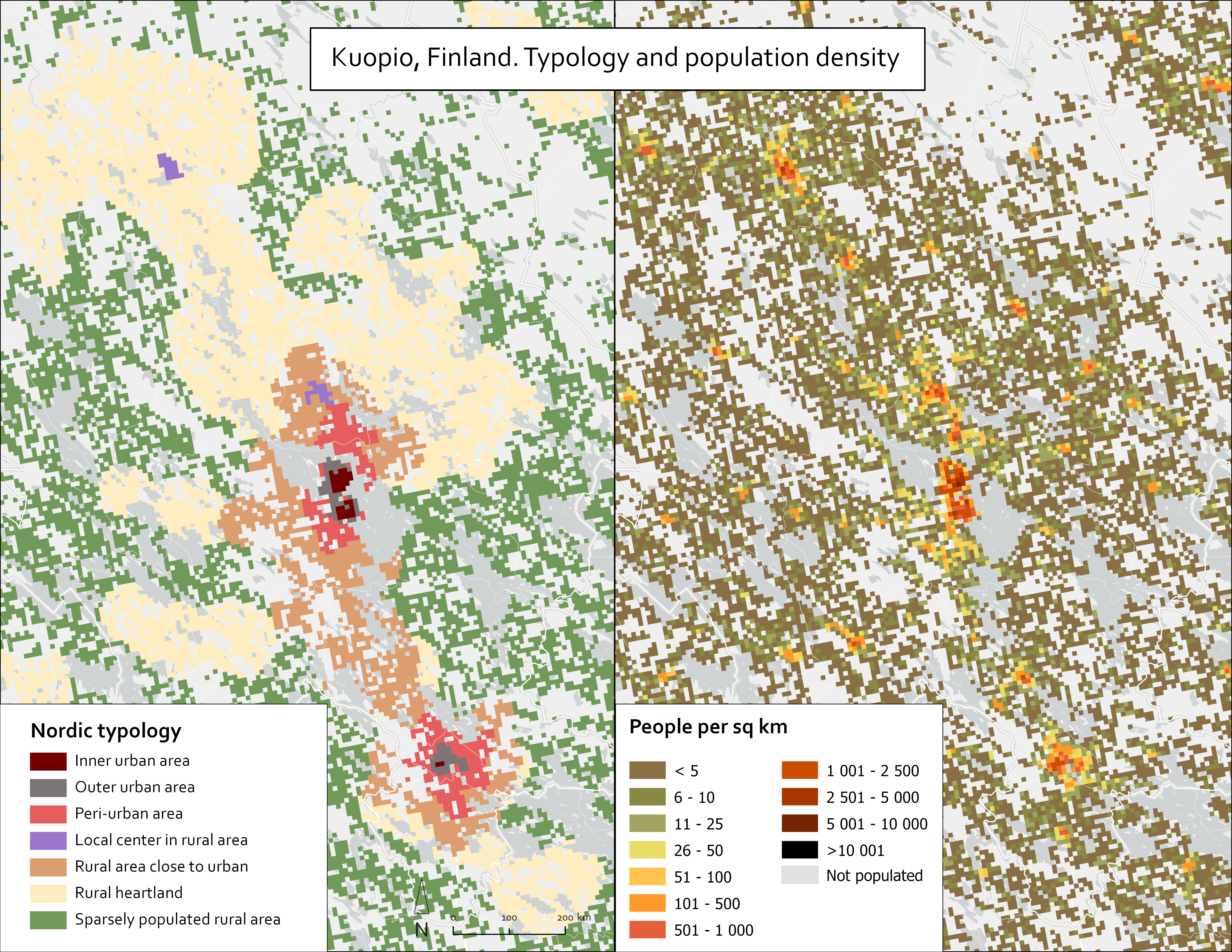
Figure 31 shows (along with Kuopio) a selection of municipalities that are classified as urban according to DEGRUBA, but where the land area is largely composed of intermediate or rural areas according to the Nordic typology (mainly peri-urban areas). The figure shows, for the municipalities of Norrköping in Sweden, Sandnes in Norway, and Aalborg in Denmark, how much of the land area in these municipalities belongs to the different territorial classes of the Nordic typology, and the proportion of the population that live in the different typology classes.
Common to all these municipalities is that they are relatively large or medium-sized towns; vast in size but have a population that live in a concentrated area in the main urban settlements. As DEGURBA classifies municipalities based on a combination of geographical contiguity and population density, the high concentration of population in the main urban settlements means that they are classified as urban. Using the Nordic typology to classify the same territories results in a largely intermediate or rural classification; there are numerous such municipalities in the Nordic countries (shown red on the map in Figure 29) including Gribskov in Denmark, Svalbarðsstrandarhreppur in Iceland, Sipoo in Finland, Løten in Norway, and Bjuv in Sweden. All are rural according to DEGURBA, while the land areas are predominantly intermediate (peri-urban) according to the Nordic typology. It is also noteworthy that while there are numerous municipalities classified as urban according to DEGURBA but are largely rural according to the Nordic typology, there are no municipalities classified rural according to DEGURBA whilst at the same time predominantly urban according to Nordic typology.
Figure 31. The proportion of land area and population in the different Nordic typology classes in selected Nordic municipalities that are urban according to the DEGURBA classification.
Another way of indicating how well the Nordic urban–rural typology and the DEGURBA classification match is shown on the map in Figure 32. The map shows how well these two classifications correspond to each other when classifying municipalities based on the territorial class in the Nordic typology where most people in the municipality live. Areas shaded grey indicate a good classification match in most Nordic municipalities. For example, most municipalities classified as urban according to DEGURBA (either inner urban areas or outer urban areas) correspond to Nordic typology classes with the most inhabitants. Also, in most municipalities that are classified as rural according to DEGURBA, the population primarily live in one of the rural classes of the Nordic typology.

However, there are some municipalities where there is a more noticeable difference between the two different territorial typologies. Shown in blue in Figure 32, both Rana in Norway (situated on the Norwegian–Swedish border), and Tornio (on the Finnish–Swedish border) are intermediate municipalities according to DEGURBA, but where the entire population live in the rural classes of the Nordic typology5.
Furthermore, the municipalities shown with the darkest shade of red (Figure 32 are categorised as rural according to the DEGURBA (but where the clear majority of the population live in areas that are classified as either urban or intermediate in the Nordic typology). For instance, the Danish municipality of Vejle is rural according to DEGURBA but approximately only 15% of the population live in rural areas according to the Nordic typology. Examples of similar types of municipalities in the other countries are Ringerike in Norway, Lempäälä in Finland, Hveragerðisbær in Iceland, and Stenungsund in Sweden, which are all rural according to DEGURBA, but where the vast majority or nearly entire population live in either urban or intermediate areas (see Figure 33).
Figure 33. The proportion of land area and population in the different Nordic typology classes in selected Nordic municipalities that are rural according to the DEGURBA classification.
A more detailed outlook on what kind of internal territorial differences can be seen within Nordic municipalities can be seen in Annex 1 and Annex 2. Annex 1 includes a dynamic graph that shows the proportion of population that lives in the different Nordic typology classes in all Nordic municipalities, while Annex 2 shows the proportion of the land area in the different Nordic typology classes in a similar way.
5 In the case of Tornio and Haparanda (both Finnish–Swedish cross-border towns) it should be acknowledged that the classification calculations in the current version of the Nordic typology were made based on the national grid of each country. Nevertheless, it is possible that carrying out these calculations in a common Nordic grid would generate a better representation of reality in these certain cross-border areas.
Territorial differences within urban municipalities
Next, a closer look is taken at territorial differences among Nordic municipalities that are categorized as part of the same territorial class in the DEGURBA classification.
We now focus on the 61 municipalities in the Nordic countries that are defined as urban according to the Eurostat typology (Figure 34). The different municipalities are shown based on the proportion of the population that live in areas that are classified as urban (inner urban areas or outer urban areas) according to the Nordic typology (y-axis), and the proportion of the territory that is classified as urban (inner urban areas or outer urban areas (x-axis). The graph is interactive, and it is possible to examine the different municipalities more closely by hovering over them in the bubble chart; it is also possible to filter municipalities according to country by clicking on the selection feature in the top left-hand corner of the graph.
Figure 34. Nordic municipalities classified as urban in the DEGURBA classification based on the proportion of the population that live in and the land area that belongs to the urban classes (inner urban areas and outer urban areas) of the Nordic typology.
Municipalities where almost the entire population live in one of the urban classes of the Nordic typology, and where also almost the entire land area of the municipality is classified as part of one of the urban classes, are shown in the upper right-hand corner of the graph in Figure 34. Specifically, these include densely populated municipalities that are part of the major Nordic urban regions, such as Copenhagen and Glasaxe in the Copenhagen capital region, Stockholm and Danderyd in the Stockholm region, and Kauniainen in the Helsinki capital region, where over 98% of all grid cells are classified as urban and where a similar proportion of the population live in these urban grid cells. The graph also shows other types of municipalities, such as those where the population largely reside in urban areas, but where the territory of the municipality is predominantly non-urban (bottom left-hand corner of the graph). For example, in Tampere and Stavanger where approximately 98% and 93%, respectively, of the population live in urban grid cells, urban areas only constitute approximately 28% of the land area of these municipalities. An even more striking example is Kuopio in Finland (discussed in the previous section) where approximately 76% of the population live in areas that are classified as urban, while the proportion of urban grid cells only constitute approximately 3% of the territory in the municipality. In the case of Kuopio, this can be related to the vast size of the municipality, which is a result of several municipal mergers during the past few of decades. The result of these mergers is that several predominantly rural municipalities which were large, but with sparse populations and few residents, were combined with Kuopio such that it became one of the largest Finnish municipalities by area (Kuopio, 2024). From this perspective, the grid-based Nordic typology helps provide a more nuanced picture of urban–rural differences within the municipality which would otherwise remain concealed if the whole municipality is classified as part of a specific territorial class.
Territorial differences within rural municipalities
Figure 35 shows the diversity of the 774 Nordic municipalities that are defined as rural according to the DEGURBA classification. Municipalities are shown (top right-hand corner of the figure) where the population predominantly live in areas that are classified as part of one of the rural classes in the Nordic urban–rural typology (y-axis) and where also the land area is primarily classified as rural (x-axis). For example, Læsø in Denmark, Ähtäri in Finland, Flóahreppur in Iceland, Balsfjord in Norway, and Pajala in Sweden are all municipalities that are rural according to the Eurostat typology, but where nearly the entire population and the land area are rural according to the Nordic typology. By contrast, in the bottom left-hand corner of the graph are municipalities that are categorised as rural according to DEGURBA, but where the land area and the population is predominantly intermediate according to the Nordic typology. These include the municipalities of Nurmijärvi in Finland, Strängnäs in Sweden, and Viborg in Denmark. A common characteristic of several of these municipalities is that they are often small or medium-sized towns, which in some cases are located relatively close to or on the outskirts of large urban regions. For instance, Nurmijärvi is located on the outskirts of the Helsinki metropolitan region. Overall, the municipalities are quite scattered (in the figure), which illustrates that those municipalities that are classified as rural in the DEGURBA classification are far from a homogenous category.
Figure 35. Nordic municipalities that are classified as rural in the DEGURBA classification based on the proportion of the population that live in and the land area that belongs to the rural classes (local centres in rural areas, rural heartland areas, and sparsely populated rural areas) of the Nordic typology.
Territorial differences within intermediate municipalities
Figure 36 shows the 288 Nordic municipalities that are classified as intermediate according to the DEGURBA classification. These municipalities are highly dispersed (in the figure), meaning that there is great variation among these municipalities in terms of how urban and rural they are according to the Nordic urban–rural typology. In the top right-hand corner of the chart are municipalities where the DEGURBA classification and the Nordic typology correspond closely to each other. Municipalities categorized as intermediate according to Eurostat typology are similarly categorized according to Nordic typology. Larvik in Norway, Paimio in Finland, and Knivsta in Sweden are examples of municipalities of this type.
The bottom right-hand corner of the graph shows intermediate municipalities where the land area is largely intermediate (or peri-urban) according to the Nordic typology, but where the population primarily live in one of the urban classes of the Nordic typology. There are several municipalities of this type in Sweden, such as Eskilstuna and Vänersborg, where over three-quarters of the population live in urban areas while over 90% of the territory is classified as intermediate according to the Nordic typology. The upper left-hand part of the graph shows intermediate municipalities, where a clear majority of the population live in the intermediate classes of the Nordic typology, while the land area is mainly classified into one of the rural categories, such as in Pieksämäki in Finland and Gällivare in Sweden. Finally, the bottom left-hand corner of the graph shows where neither the population nor the land area of the municipality is intermediate according to the Nordic typology. These include Järvenpää in Finland and Ballerup in Denmark, located in major urban regions, and where both the land area and the population belongs almost entirely to one of the urban classes. Among these municipalities is also the previously highlighted example of Rana in Norway, which according to DEGURBA is an intermediate municipality, while the Nordic typology classifies both the population and the land area as entirely rural.
Figure 36. Nordic municipalities that are classified as intermediate in the DEGURBA classification based on the proportion of the population that live in and the land area that belongs to the intermediate classes (peri-urban areas and rural areas close to urban areas) of the Nordic typology.